More aerial touring of S.C.
This afternoon I took my Dad up for a flight out of KUZA in the CH2000. The goal was to get some video and pictures of his friend’s place, where my Dad goes hunting, as well as the family land in Fairfield county, SC.
We took off and headed to his friend’s house first, where we made a multitude of steep turns to the right over his property. We did a few passes with the video camera and then 2 with the still camera. It was tough to keep my distance from his house while still keeping the low wing out of the picture. I would start a nice little “turn around a point” and then need to really drop the wing so my Dad could get a few seconds of good picture taking time.
We performed similar maneuvers over our family land further south before heading back to fly-by my dad’s childhood house, then his and my Mom’s current house, then back to KUZA for an “on-par” landing.
I enjoyed flying out of KUZA – it is a really nice size runway with plenty of room around it for a comfortable approach, unlike my normal KJGG home base which makes you feel a little claustrophobic.
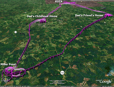
Here’s my now-mandatory Google Earth GPS track file from the flight (screenshot of it shown below – we went east first). BTW, it appears that Google Earth can now read GPX files directly, bypassing the need to convert them via magnalox.com. Maybe it can read right off the GPS now too, haven't tested that.
We took off and headed to his friend’s house first, where we made a multitude of steep turns to the right over his property. We did a few passes with the video camera and then 2 with the still camera. It was tough to keep my distance from his house while still keeping the low wing out of the picture. I would start a nice little “turn around a point” and then need to really drop the wing so my Dad could get a few seconds of good picture taking time.
We performed similar maneuvers over our family land further south before heading back to fly-by my dad’s childhood house, then his and my Mom’s current house, then back to KUZA for an “on-par” landing.
I enjoyed flying out of KUZA – it is a really nice size runway with plenty of room around it for a comfortable approach, unlike my normal KJGG home base which makes you feel a little claustrophobic.
Here’s my now-mandatory Google Earth GPS track file from the flight (screenshot of it shown below – we went east first). BTW, it appears that Google Earth can now read GPX files directly, bypassing the need to convert them via magnalox.com. Maybe it can read right off the GPS now too, haven't tested that.