IFR flight #15 - first cross country
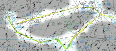
Today I did my first cross-country IFR flight. Charles and I went from JGG to ROA to AVC to JGG over 4.8 hours of flight time. Needless to say, I was worn out at the end of that trip.
Last night I used the AOPA flight planner to determine my routes for the trip and to print out nav logs, and flight plan templates for later use when filing flight plans. This morning I filed via DUATS for the leg to ROA - I used the flight planner to do that and really liked that feature.
We left around 1pm with (generally) good weather forecast for the entire trip - light winds, a few clouds at 5000 feet AGL. After the pre-flight and a final check of the radar internet pictures we taxied out to 13 to do the run-up and instrument checks. I called up Norfolk on the GCO frequency and received the clearance. I had some trouble understanding the clearance due to the controller's accent, but eventually got it all copied down (and repeated) correctly. She cleared us to 4000 feet and direct to Wakefield, then as filed. I had filed the trip to take us west to the Hopewell VOR, then to the VOR on the field at Richmond, and on west to the Flat Rock and then Lynchburg VORs, then ROA. I originally planned the trip to fly the ILS 33 at ROA, but the notams told me that the ILS and the nearby NDB were not functioning, so Charles and I planned on shooting the LDA 6 approach instead. This meant that we'd need to climb higher than my filed 4000 cruise altitude at some point, to clear the mountains in ROA.
So back to the flight itself...after getting the clearance I realized that I had lost the foggles I was keeping in my lap. It is very frustrating to search a small airplane while you are sitting in it with the engine running. After not finding them with a few minutes of searching we had to stop looking due to our clearance expiration time. Luckily Charles had his pair of foggles, so I was able to use them. We did an instrument takeoff (one where I wear the foggles) and departed 13 a few minutes after an old tail dragger war plane took off (making a massive amount of really cool noise).
When we reached a few hundred feet above ground level we turned toward Wakefield and called up Norfolk approach on the radio. I think we were around 700 feet AGL at that time and even when we ident'd for them they couldn't see us. They asked for another ident around 1,700 feet and then they had radar contact with us. They immediately cleared us direct to the Hopewell VOR and then as filed in the flight plan.
After making the adjustment to track into Hopewell I started trying to wrap my head around how to properly follow airways. This was the first time I had done that so I had to jog my memory a bit about the ground work I had done on the subject. One thing that tripped me up was dialing in the radial heading into the OBS when I was tracking inbound to the VOR. Since I was heading in the exact opposite direction of the radial value, that caused reverse sensing on the VOR indicator. Charles pointed that out to me quickly so that I would not start getting off course and I corrected by turning the OBS to the reciprocal heading. The fact that I was still getting my head screwed on straight with tracking radials while also fighting thermals and talking on the radio had me quickly realizing how challenging IFR flight is. Charles pointed out that I had a death grip on the yolk and told me to relax or I'd pass out after of hour or so from exhaustion. :) I tried to minimize my effort in flying the airplane but the thermals had me pushing the nose down and then level again over and over. Good arm workout, but kind of annoying. I guess that's where the autopilot is your best friend.
We went through a few small clouds on the way out from JGG and simply catching a tiny view of them from underneath the foggles was a bit disorienting. That was my first flight in any type of significant clouds. I concentrated on the attitude indicator. Even though it said I was wings level I felt like we were banked 15 degrees to the right. I ignored what my body was saying and trusted in the instruments. Eventually the feeling went away and my body synced up with the instruments. Good learning experience.
When we reached 4000 feet we leaned the engine to a fuel flow of 10 gallons/hr hoping to minimize spark plug fouling and save some fuel.
After crossing the Hopewell VOR we continued north to the Richmond VOR over that airport. Washington Center had us make a few heading diversions to avoid traffic leaving RIC. On the way west from Richmond we had an MD-80 climbing underneath us and heading to our left. I caught a glimpse of him from under the foggles and had to cheat to take a look at him for a second or two. It is not often that you see one of those jets in-flight below you. Washington Center made various traffic calls to us while we were close to RIC but after 15nm or so we were out of the way.
After we passed Flat Rock we were told to climb to 5,000 feet and to expect the visual approach into ROA. We requested the LDA 6 and were told that they would pass the request on for us. I continued to fight the thermals - sudden 500 ft/min climb, followed by me correcting it back down to 5000 feet and then yet another thermal in 30-40 second cycles. Before we reached the Lynchburg VOR we were vectored to the south a bit on a heading of 250. We needed to come in on the south side of the airport in order to come in on the runway 06 approach we wanted. We stayed on that heading for a while until we were slowly vectored to point to north, toward the field. I started to notice that we were getting a bit close to the field and still a few hundred feet higher than the normal intercept altitude for the LDA 6 approach. I saw the glideslope starting to come in but since we were not cleared for the approach I did not have permission to follow it down. I continued straight ahead and then was told what was going on; we were getting vectored out of the way of some faster traffic. We were told to generally circle around to the left and were then cleared down the LDA 6.
The approach went fairly well. I had the needles fairly stable the majority of the way down, and did the before landing checklist right after starting down the glideslope. I contacted the tower just after the checklist was done to tell them I was with them. She immediately cleared me to land on 06. I got a little high toward to end of the approach but kept the localizer centered fairly well. Charles told me to take the foggles off and look for the runway, which at that point was just in front of us, slightly left of the nose. I put in some flaps, slowed up the airplane, and came in for a decent landing. They had us exit to the right on the first ramp and told us to contact ground-point-9 (121.9). We got past the threshold and stopped to clean up the airplane - raise the flaps, kill the strobes and landing light, turn the transponder to stby. I called ground and asked to taxi to the "piedmont" FBO. They cleared us to taxi off to the right and then to the left and the runway intersection. The FBO was a little ways down on the left side, with a few small jets parked on its ramp. The ground personnel had us park just off the taxi-way at the FBO, close to the grass. Checking the fuel, we had used almost half a tank of gas, and 2.4 engine-on hours to get to ROA. We asked for a fill-up. My enroute airtime estimate was 1.5 hours. I'd estimate we spent about 45 minutes more than that enroute. Some of that was due to the ATC diversions, some of it to my power settings being a touch low after we climbed from 4000 to 5000 (I had planned for 110kts @ 2200 RPM).
I closed up the airplane and Charles and I went into the FBO to relax a bit and plan the next leg of the flight, this trip to KAVC, Mecklenburg-Brunswick. The FBO was quite nice, very cool temps and a nice flight planning room with a computer and direct-dial flight service phone to talk to Leesburg FSS. They had a den-type room with low lighting, overstuffed chairs, and a TV. If we had had time, I would've taken a 1 hour nap to try to reset. But alas, the cross-country was calling me back and the stress of "keeping going" is a big part of the point of the trip. I put the 23 gallons of gas on my credit card, all $86 of it, and we headed out to the airplane. I joked with Charles that I hoped we could find some foggles out in the plane, since I had not yet looked for the pair I managed to lose on the JGG ramp. I was lucky and Charles spotted them between the seats quickly. I did a good overview preflight and we checked the oil (still at 7 qts) and looked for contaminants in the fuel (a drop of water out of the right wing inboard).
With no new dents in the airplane and the fluids looking good to go, we hopped in and cranked up the engine. I sorted through the charts I had out: the local departure procedures in case we needed them, the local airport diagram, and the two approaches into our new destination, AVC. After Charles had a closer look at the DPs we realized that they did not apply to runway 6 due to obstacles, so that meant it was unlikely we would use them. We called up clearance delivery and told them "5199A is at piedmont, IFR to Mecklenburg-Brunswick, request IFR clearance". They gave us our clearance: climb to 5000, turn 070 after takeoff, direct to south Boston VOR, then as filed (AF), squawk 4056. This was nice b/c they gave us a little shortcut with the direct-to-SBV. After setting up the radios based on the clearance instructions, we called up ground and asked to taxi. They told us "cleared to taxi to E, then cross 31, then E to runway 06". It was time to head out to the runway. I started to put the foggles in my lap, to free my hands for the taxi trip and thought better of it, since I had already lost them once today doing that. I looked around for a decent place to put them and, not finding one, I looked at Charles and tossed them his direction. We both knew they'd be safer over there.
Using the airport diagram to determine how to get to taxi-way E, we headed off to the left and over to runway 06.
We got abeam the approach end of runway 6 and went off into a corner to do our run-up check. We had a bad mag on the left side, so we leaned to mixture with the throttle at 2000 RPM for 30 seconds to clear it out. It worked fine after that. This was just due to running it a bit rich for the humidity levels, I believe. I had forgotten to do the instrument checks while taxiing so we did those on the way to the threshold. When we were at the threshold, I called up the tower and told them we were ready to go at 06. They cleared us for takeoff.
We taxied onto the runway, after looking for landing traffic, and I put on the foggles. We made an instrument takeoff and, at 60 kts of airspeed, pulled up gently into the air. We maintained runway heading for a few hundred feet and then turned right to our assigned 070 heading. A few more hundred feet up and the tower handed us over to Roanoke Departure. We called them up: "Roanoke Departure, Cessna 5199A is with you at 1,600 for 5,000". They told us to continue our climb for a while and then cleared us to go direct to the SBV VOR.
We already had it tuned into the radio, so we turned up the nav radio volume to verify the signal's Morse code, and turn to track directly to the station. After a while we reached the SBV VOR and turned left to follow V266 to the HARVY intersection. At this point ATC directed us toward making a visual approach into AVC and we turned around and requested the LOC-1 approach. They approved this and gave us some vectors to the AEA NDB at or above 2,000 feet MSL. We started our descent and used the GPS to identify the NDB (it is part of the approach). When ATC cleared us to switch frequencies to the local Unicom we went ahead and cancelled our IFR flight plan. We made a tear-drop entry into the hold over the NDB in order to get oriented and turned around to go down the localizer. We also used it to lose some altitude when coming inbound b/c the approach allows for you at 1700 when tracking inbound to the NDB along the localizer. We switched to the CTAF frequency for AVC and asked for advisories from Unicom. No one responded (and they don't have an automated wx station) so we decided we would go for the straight-in approach instead of circling to land in the opposite direction.
We continued toward the airport and, when we were fairly close to the airport and the missed approach point, Charles had me remove the foggles and setup for the touch and go. We were quite high so I immediately pulled the power back and, eventually, put in all the flaps. I was putting the flaps in a bit slow and Charles advised me to be a bit more aggressive about getting them in, which made perfect sense since we definitely needed them to help us drop. We touched down a little long on the runway, threw the flaps back up into the wings, and put in all the power to take off again.
At a few hundred feet AGL, Charles took the plane to allow me to put the foggles on again. He then told me to turn right to 060, which I did a bit early (I should have waited until we were close to 1000 AGL). Then he covered up the attitude and heading indicators so we could do some partial panel / no-gyro work. We were tracking direct to the Hopewell VOR and I realized that it was the first time I had tried to track a VOR signal when on a partial panel. It was fairly difficult, though certainly not impossible. I found myself shooting through the desired course and basically making slight s-turns the entire time, so there was plenty of room for improvement. We continued tracking the VOR for a bit, and then just went to maintaining heading.
When we were just north of the HIGAL intersection (which is a few miles due north of JGG) Charles had me make the VOR approach to Williamsburg.
Even on the approach I was doing a bit of s-turning, but it was a little improved. When we reached HIGAL I descended to the minimum altitude and when I was told to take off the foggles and look for the field, we were a bit too far to the West of the field. We crossed mid-field and circled around for a right-hand traffic landing on 13. I flared a bit early on the landing and we hit with a little more of a thump than I would have liked. But considering how worn out I was mentally and physically, it wasn't too terrible.