IFR to Asheville, NC
This weekend we flew ~3 hours in the C-172 to Asheville, NC. The rest of the Miller family was out there for a bit of vacation time and we had a mind to join them.
JGG was fairly busy for a Friday @ 2pm. There were about 5 police choppers at the field with what I assumed were some of their pilots upstairs in the terminal meeting one another. There were also various fixed-wingers coming and going.
K started the preflight while I bought the required charts for the trip. Since there was a slight threat of T-storms and already plenty of building clouds in the area I filed IFR and picked up the appropriate approach plates, sectionals, and low-altitude enroute charts. I filed my flight plan with “VFR GPS on board” in the remarks and nothing in the route (direct route). I wanted to see if I could get a direct route with no IFR GPS (pilots I trust had already told me it was quite OK).
Preflight and bathroom breaks complete, we started out to runway 13. I stopped in my normal engine run-up spot which is actually on the ramp (not the taxiway). Before I was in position I heard another chopper state that they were coming in to the ramp. Since there were plenty of other choppers right beside my run-up spot, I thought he would be coming close. Well, that guess was accurate. I switched over to the GCO (ground communications outlet) to get my IFR clearance. Part way into that, K told me that the chopper was hovering; waiting on us to move. I felt bad that he was probably trying to raise me on UNICOM to see what was up and I wasn’t there to respond. Since I was on the line with Norfolk ATC already, I stayed on the GCO frequency and just moved out of his way immediately. He landed in my spot right away.
I parked a short distance away and started writing down the clearance using the CRAFT mnemonic:
The airplane was climbing a little slow due to the warmish temps and the amount of stuff we were carrying with us. On the climb out to 3000 feet we were cleared on up to 5000. This is what we saw in front of us:
It became obvious that we would enter those clouds soon so I put on my IFR hat and started getting ready to ignore all seat-of-the-pants input.
Before even reaching 5000 feet we were cleared on up to 8000. Just as we finally hit 8000 after the slow climb out (especially slow over 6000 feet) we entered a building cloud. Of course, while that cloud was busy building itself up taller, it was more than happy to take us up for a little elevator ride. I would have loved that help in the climb out, but now I have to start fighting it to get back down to 8000’. ATC came on to make sure we weren’t accidentally passing through our assigned altitude and I keyed the mic to thank him for the help as I put in some good nose down correction. We were also getting some roll changes due to the bumps so I focused momentarily on the attitude indicator to correct them. After a few minutes we were out of that cloud and started picking a route around the next build ups on our way to the FKN VOR.
 A few minutes later we were cleared to go direct to AVL . The rest of the trip to AVL mostly consisted of dodging build-ups.


However, after hearing ATC give weather notices to various other planes in the area, one soon came for us. We were advised of an area of precipitation ahead that was moderate to extreme. ATC suggested we divert to the south to avoid it. Since I couldn’t see it yet, I thanked them for the information and pressed forward, eyes peeled. Once we passed a few more build-ups the rain they mentioned was finally in sight. I saw some white areas to the north, but it looked like if we went that way we might not be able to stay out of the clouds for long. I wanted to avoid getting in the soup since my eyeballs were my primary weather avoidance system. So we diverted south as ATC suggested.
As we passed it to the South K snapped this photo to the right of us:

And to the front (this was the lesser part of the precip, we were 50’ under the darkest part of the cloud):

After passing by that precip, we had one more to dodge. Then Krista saw this off on the right side as I was starting to negotiate the mountains near AVL.
 This was the closest we came to a mountain top (Little Pisgah Mountain) and it was close enough for me (~1400’ AGL):
 Shortly after that we were turned on a massive downwind leg for runway 16 (that’s what we get for being the slow boy in town) and eventually turned in behind a fast-mover to follow him to the airport:

 The trip was a great one – I gained a good bit of IFR experience in avoiding weather as well as a bit of actual time on the instruments. K enjoyed the flight but said she was glad I was in the left seat on this one. I think the low visibility at times, especially in the mountains, had her on edge. Me too.
Two things that were especially helpful on this trip:
JGG was fairly busy for a Friday @ 2pm. There were about 5 police choppers at the field with what I assumed were some of their pilots upstairs in the terminal meeting one another. There were also various fixed-wingers coming and going.
K started the preflight while I bought the required charts for the trip. Since there was a slight threat of T-storms and already plenty of building clouds in the area I filed IFR and picked up the appropriate approach plates, sectionals, and low-altitude enroute charts. I filed my flight plan with “VFR GPS on board” in the remarks and nothing in the route (direct route). I wanted to see if I could get a direct route with no IFR GPS (pilots I trust had already told me it was quite OK).
Preflight and bathroom breaks complete, we started out to runway 13. I stopped in my normal engine run-up spot which is actually on the ramp (not the taxiway). Before I was in position I heard another chopper state that they were coming in to the ramp. Since there were plenty of other choppers right beside my run-up spot, I thought he would be coming close. Well, that guess was accurate. I switched over to the GCO (ground communications outlet) to get my IFR clearance. Part way into that, K told me that the chopper was hovering; waiting on us to move. I felt bad that he was probably trying to raise me on UNICOM to see what was up and I wasn’t there to respond. Since I was on the line with Norfolk ATC already, I stayed on the GCO frequency and just moved out of his way immediately. He landed in my spot right away.
I parked a short distance away and started writing down the clearance using the CRAFT mnemonic:
- C (Clearance):Cleared to KAVL via heading 230 into controlled airspace
- R (Route): FKN VOR – expect “as filed” within 10 mins
- A (Altitude): 3000, expect 8000 within 10 mins
- F (Departure Freq): 124.9
- T (Transponder Code): 6217
The airplane was climbing a little slow due to the warmish temps and the amount of stuff we were carrying with us. On the climb out to 3000 feet we were cleared on up to 5000. This is what we saw in front of us:

It became obvious that we would enter those clouds soon so I put on my IFR hat and started getting ready to ignore all seat-of-the-pants input.
Before even reaching 5000 feet we were cleared on up to 8000. Just as we finally hit 8000 after the slow climb out (especially slow over 6000 feet) we entered a building cloud. Of course, while that cloud was busy building itself up taller, it was more than happy to take us up for a little elevator ride. I would have loved that help in the climb out, but now I have to start fighting it to get back down to 8000’. ATC came on to make sure we weren’t accidentally passing through our assigned altitude and I keyed the mic to thank him for the help as I put in some good nose down correction. We were also getting some roll changes due to the bumps so I focused momentarily on the attitude indicator to correct them. After a few minutes we were out of that cloud and started picking a route around the next build ups on our way to the FKN VOR.
 A few minutes later we were cleared to go direct to AVL . The rest of the trip to AVL mostly consisted of dodging build-ups.

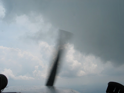
However, after hearing ATC give weather notices to various other planes in the area, one soon came for us. We were advised of an area of precipitation ahead that was moderate to extreme. ATC suggested we divert to the south to avoid it. Since I couldn’t see it yet, I thanked them for the information and pressed forward, eyes peeled. Once we passed a few more build-ups the rain they mentioned was finally in sight. I saw some white areas to the north, but it looked like if we went that way we might not be able to stay out of the clouds for long. I wanted to avoid getting in the soup since my eyeballs were my primary weather avoidance system. So we diverted south as ATC suggested.
As we passed it to the South K snapped this photo to the right of us:

And to the front (this was the lesser part of the precip, we were 50’ under the darkest part of the cloud):

After passing by that precip, we had one more to dodge. Then Krista saw this off on the right side as I was starting to negotiate the mountains near AVL.
 This was the closest we came to a mountain top (Little Pisgah Mountain) and it was close enough for me (~1400’ AGL):
 Shortly after that we were turned on a massive downwind leg for runway 16 (that’s what we get for being the slow boy in town) and eventually turned in behind a fast-mover to follow him to the airport:
 The trip was a great one – I gained a good bit of IFR experience in avoiding weather as well as a bit of actual time on the instruments. K enjoyed the flight but said she was glad I was in the left seat on this one. I think the low visibility at times, especially in the mountains, had her on edge. Me too.
Two things that were especially helpful on this trip:
- ATC Weather reports – absolutely invaluable. We would have had a crummy ride through that biggest rain cloud if they weren’t helping me out
- The terrain page on the Garmin GPSmap 296 – that made K feel much better because we could “see” the terrain as we maneuvered near AVL