Posts

Showing posts from November, 2005

More aerial touring of S.C.

Image
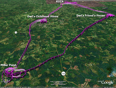
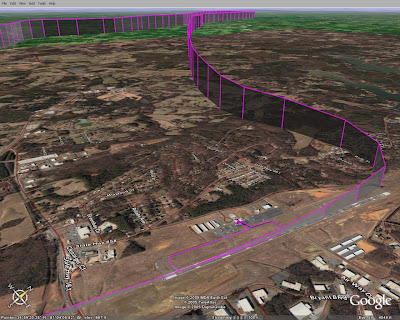
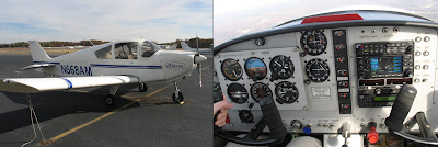
This afternoon I took my Dad up for a flight out of KUZA in the CH2000. The goal was to get some video and pictures of his friend’s place, where my Dad goes hunting, as well as the family land in Fairfield county, SC. We took off and headed to his friend’s house first, where we made a multitude of steep turns to the right over his property. We did a few passes with the video camera and then 2 with the still camera. It was tough to keep my distance from his house while still keeping the low wing out of the picture. I would start a nice little “turn around a point” and then need to really drop the wing so my Dad could get a few seconds of good picture taking time. We performed similar maneuvers over our family land further south before heading back to fly-by my dad’s childhood house, then his and my Mom’s current house, then back to KUZA for an “on-par” landing. I enjoyed flying out of KUZA – it is a really nice size runway with plenty of room around it for a comfortable approach,

A solo tour of northern S.C.

Image
This morning I decided to take advantage of my holiday vacation to get some more practice flying the Alarus CH2000. The family was all out doing their Black Friday shopping, so I was left to fly solo. Since this was the first time I had a chance to fly solo in Rock Hill, SC since 1996 I decided to make an aerial trek to nearby Crowder’s Mountain. Really it is a craggy hill but since it is surrounded by flat land a hike to its peak gives great views of the area. Of course, the views you get on a hike don’t match those from 3000 feet in an airplane, so I enjoyed the sights from my lofty perch. I simply made a quick left hand turn around the mountain and headed back to over-fly my parent’s house. From there it was a quick left hand turn to get lined up on a long final for runway 02 at UZA. I used the Garmin 430 to tune in the ILS on the way down but saw weird indications from the glideslope needle. The needle was bouncing up and down though the flag seemed to indicate it was gettin

Checked out to fly the Alarus CH2000

Image
While visiting with the parents for Thanksgiving I decided to go to the local airport to get checked out in a plane I haven't been in before: an Alarus CH2000 . This is a minimalist IFR trainer that has a nice set of avionics on board. It is a small plane, with 2 seats, that, I believe, shares the same engine as a C-152. My first impression of it while preflighting was that it was flimsy feeling. The doors are very thin and light, and the overall design of the airplane seems pretty bare bones. But once I hopped in it felt just fine. My checkout instructor, Nate, walked me through the systems before we took off to the south for a little airwork. We did some slow flight and found that when we pointed the nose right into the wind we could get our ground speed down as low at 15 kts (using the onboard Garmin 430 for the groundspeed readout). The airspeed indicator was reading 20 kts when it would finally stall in a landing configuration. In general, the slow speeds of the air

A relaxing afternoon flight

Image
I just finished one of the most relaxing flights I have had in a long time. I spent 1.1 hours in the local area, with no set plan, just enjoying flying for flying's sake. Had a little bit of fun starting the Arrow today. Recently the starter will not engage until you turn the prop a little, so you get yourself all belted in and go to start it, only to find that you have to hop out and turn the prop maybe half way around to get the starter gear seated. But after that it started right up. I had to cancel an early morning flight yesterday because I ran out of battery power before I could get the engine to start in the 32 degree temp (I only ran the starter 30-40 seconds total, so maybe the battery was still asleep that morning). But back to today: I shot a landing at FYJ where I had to wait on the taxiway for parachuters to land, I did a stall and a steep turn, and a quick landing down the ILS7 at PHF. Then it was back to JGG where I had a fairly decent touchdown.

Shooting an ILS approach with Microsoft Flight Sim

I thought I'd write up this quick tutorial on shooting an ILS approach with MS Flight Sim for 2 reasons: 1) as an exercise for myself to make sure these procedures are solidly still in my head, and 2) because I have seen that there is some interest in it from VectorsToFinal.com readers. Disclaimer: I am no instructor, so take all this with a critical eye. If I say anything flat out wrong in here, please let me know, but I won't pretend to make this a complete tutorial - some stuff will be left out. :) For this flight, we will ignore ATC completely (which is obvious a terribly bad idea in real life or multiplayer sim games). Before reading my write-up, I'd recommend you take a look at this post from a real-life flight instructor to gain some context. Here's my tutorial (in 1.5MB PDF form) .

Fun with GPS overlays

Image
UPDATE - 2007: MapSource makes this easy for Garmin handhelds now - they have added a "show in Google Earth" option. This morning I stumbled on a blog about using Google Earth with GPSs . Determined to finally get my copy of Google Earth to show a track file from my GPSmap 296, I followed a few of the links from that blog to decipher how to do it. Google Earth is supposed to read the data right off the GPS, once you pay the $20 to upgrade. However, there are apparently well known problems using a Garmin USB device with it, so you have to go a ‘round about way. The way I finally made it work was this (see comments below to learn how this is the TOO LONG way to do it): Use Garmin MapSource to download the track files from the GPS Save the MapSource file (a .gdb file) Use the graphical interface of GPSBabel to convert the GDB file to a GPX XML file Open this XML file in excel – Excel will load the data from it into columns Pull the 3 columns that matter out of that file and c

Second Flight to the Wright Brother's National Memorial

Image
Today we decided to do a little cross country flight back down to First Flight airport, near Kitty Hawk, NC. We had planned to travel west to Roanoke, VA to see the leaves change colors in the mountains, but a storm front over the Blue Ridge range made us decide to go south instead. It was a nice flight, with some winds making the landings interesting. Coming back into Williamsburg at 2pm was particularly interesting – the AWOS weather report was saying that there were near 90 degree crosswinds at 11 kts, gusting to 17. Seeing as how 17 knots is just above the limit for a crosswind in the Arrow we were flying I was on my toes for that approach. I almost had to go around when high winds at 500 AGL were blowing us way off centerline. The wind let up enough for me to correct mere seconds before I was going to put the throttle in and try again. My touchdown was OK but I could use some improvement on getting rid of the side-loads as the wheels meet the ground. That is tough to practi